
 Pelagic Habitat Analysis Module (PHAM)
A set of Windows based software tools designed to assist fishery managers, scientists, and researchers.
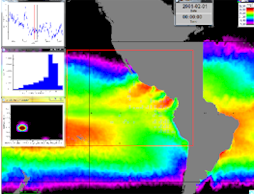
With PHAM you can import measurement data and imagery to analyze, display, and export likely habitat based on multi-dimensional imagery analysis. PHAM can be used to:- Import imagery and other datasets:
- Satellite imagery
- Bathymetry
- Coastline
- Ocean current data
- ArcShape data
- Your own data (e.g. survey cruise data)
- Integrate and display data as blob plots, coutours, or false color images overlaid on imported imagery.
- Convert ASCII measurement data (lat/long or sample values) to false color images
- Run a dynamic simulation of measurement data and imagery over a desired time period.
- Look up imagery values at the location and times of your sample data.
- e.g. Clorophyll, oxygen, sea surface temperature
- Graph imagery statistics:
- Distribution of imagery measurement values
- Correlation between any two imagery types
- Analysis of variance for any two imagery types
- Export results, including:
- Sample data and associated imagery values
- Calculated statistics.
- Imagery in any of the following formats: bmp, gif, jpg, png, tif, or NetCDF
For more information, contact:
Dr. Dale Kiefer
System Science Applications
Email : support@runeasy.com
PHAM was developed under a NASA grant through the Applied Sciences Program and was featured in their Annual Report.
PHAM is a component of the Environmental Analysis System (EASy) Geographical Information System (GIS) developed by System Science Applications, Inc. specifically for marine applications.